The Importance of Point “F”
This article was translated automatically and may contain differences from the original. For reference, read the original.
El Mostrador, February 7, 2021
With a surprising naivety, in the attempt to justify Chilean support for Argentina’s claim of sovereignty over territory under British sovereignty, the Director of Borders and Limits does not analyze what lies behind it, what strategy Argentina is pursuing in its claim—certainly inapplicable to Chile—of its extended continental shelf, nor the serious consequences this claim has for Chile’s interests. The key to understanding the trap posed by Argentina does not lie in the technical-legal interpretation of the facts, but in the analysis of Argentina’s national objectives and interests, which are openly declared or easily deduced from its behavior over time. For some time, Argentina has used the argument that Chile should be in the Pacific and Argentina in the Atlantic. When the American continent sinks into the sea, where is the separation between the Atlantic and the Pacific? Argentina’s strategy has always aimed to position the separation between the two oceans at the meridian that passes through Cape Horn. This strategy allows Argentina to project the meridian from Cape Horn to the South Pole, thereby leaving almost the entire Antarctic Peninsula under Argentine sovereignty.
Following the unfortunate bilateral statement at the end of the Argentine president’s state visit to Chile and the attempt to justify Chilean support for Argentina’s claim of sovereignty over territory under British sovereignty, made by the Director of Borders and Limits of the State on El Mercurio on January 30, an important debate has arisen regarding the quality, intensity, and timeliness of the defense of Chilean national interest in light of Argentina’s territorial and maritime claims in the southern region. The objective of this column is to clarify what is at stake and why it is important for everyone to understand the issue, despite its complexity.
At the root of the problem is the blatant violation of the norms and spirit of the Treaty of Peace and Friendship of 1984, committed by Argentina in its attempt to project its extended continental shelf south of Point “F,” established in that treaty as the last “definitive and unmovable” boundary of the delimitation of maritime spaces, land, and subsoil between Chile and Argentina. The Director of Borders and Limits, in her published article, provides a lengthy technical and legal explanation of what the extended continental shelf is. Unfortunately, she fails to recognize that foreign relations are political relationships, involving interests and power, with a legal component, and not the other way around. With a surprising naivety, our Director of Borders and Limits does not analyze what lies behind it, what strategy Argentina is pursuing in its claim—certainly inapplicable to Chile—of its extended continental shelf, nor the serious consequences this claim has for Chile’s interests.
The key to understanding the trap posed by Argentina does not lie in the technical-legal interpretation of the facts, but in the analysis of Argentina’s national objectives and interests, which are openly declared or easily deduced from its behavior over time. For some time, Argentina has used the argument that Chile should be in the Pacific and Argentina in the Atlantic. When the American continent sinks into the sea, where is the separation between the Atlantic and the Pacific? Argentina’s strategy has always aimed to position the separation between the two oceans at the meridian that passes through Cape Horn. This strategy allows Argentina to project the meridian from Cape Horn to the South Pole, thereby leaving almost the entire Antarctic Peninsula under Argentine sovereignty.
That separation between the Atlantic and the Pacific is arbitrary, as only land generates rights over the sea, not the other way around. The arbitration award of Her Majesty the British Crown and the Treaty of Peace and Friendship of 1984 leave no doubt regarding Chilean sovereignty over all land existing south of the Beagle Channel, and therefore that land generates rights over the sea, land, and subsoil, including the continental shelf and the extended continental shelf. The delineation of the maritime boundary in the TPA is somewhat strange, but we ultimately accepted it. We were significantly disadvantaged by that delineation, but it was understood as the price for peace and the definitive delimitation of the controversy that we were prepared to defend with the lives of young Chileans in December 1978.
Although we do not like the provisions of the TPA, considering it unbalanced in favor of Argentina, we recognize that it contains some essential elements to avoid problems in the future. One of those essential elements is to eliminate once and for all the arbitrary dividing line between the Atlantic and the Pacific at the meridian of Cape Horn. This is clearly, distinctly, and emphatically established in the TPA of 1984, and specific safeguards were expressly established in the treaty for this purpose.
The first safeguard is in Article 9 of the TPA. That article establishes that it will be called “Sea of the Austral Zone”to all the maritime space delimited in the TPA, thereby expressly erasing any attempt to establish the geographical division between the Atlantic and the Pacific at the meridian of Cape Horn. In paragraph 2 of Article 14, a clause was established that affects Article 7 of the treaty and states that the maritime delimitation constitutes
“a definitive and unmovable boundary” between both sovereignties, meaning that Point “F” cannot move beyond the limit of both sovereignties, not only at sea but also on land and in the subsoil. In Article 14, the parties committed to
“not present claims or interpretations that are incompatible with what is established in this Treaty.” , which prevents, in the exclusive context of the TPA, and although the Convention on the Law of the Sea allows it, any claim that its limits at sea, on land, and in the subsoil extend south of Point “F.”Finally, making a clear and express reference to the Antarctic projection, Article 15 of the TPA established that the provisions on the maritime delimitation of the treaty
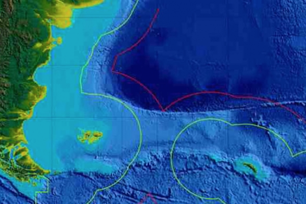
“shall not affect in any way nor may be interpreted in the sense that they may affect, directly or indirectly, the sovereignty, the rights, the legal positions of the Parties, or the delimitations in Antarctica or in its adjacent maritime spaces, including the land and subsoil.” As we can see, the importance of Point “F” lies in that it constitutes a definitive and unmovable point of maritime delimitation of the sea, land, and subsoil between Chile and Argentina, and it not only produces the positive legal effect of constituting the end of the limit of both sovereignties, but also produces the negative geopolitical effect of expressly preventing the projection of the meridian of Cape Horn to the south, beyond Point “F,” towards Antarctic territory. For these reasons, the unilateral interpretation and claim by Argentina of a sector of the extended continental shelf (“which extends from the spur of Tierra del Fuego under Argentine sovereignty north of the Beagle Channel”) in accordance with the rules of UNCLOS, which are subsequent to the ratification of the TPA, flagrantly violate the letter and spirit of the treaty.
Indeed, the claim for a wedge of extended continental shelf south of Point “F” has the effect of unilaterally displacing the boundary of both sovereignties, and the Argentines do so while carefully maintaining the meridian of Cape Horn as the western limit of their claim. This attitude not only violates the TPA but also creates a new endpoint for the maritime delimitation, outside the
“Sea of the Austral Zone” conceived to prevent any argument that the division between the Atlantic and the Pacific is the meridian of Cape Horn, and it removes from Point “F” its legal nature as a “definitive and unmovable boundary.” This sets the stage for an interpretation and claim that is“incompatible” with the limit established bilaterally by the TPA and affects, “directly or indirectly, the sovereignty, the rights, the legal positions of the Parties, or the delimitations in Antarctica or in its adjacent maritime spaces, including the land and subsoil.” This Argentine action, rather than claiming a tiny area of marine land and subsoil as an extended continental shelf south of its EEZ, seeks to displace the endpoint of the limit further south, along the meridian of Cape Horn. This claim seeks to seriously contravene Chilean rights regarding our Antarctic territory, as the geopolitical race for Antarctica is already unleashed both at the level of great powers and among countries with sovereignty claims on the frozen continent. In that context, the Argentine claim aims to support its territorial claim in Antarctica based on its incorrect new endpoint of maritime delimitation, which, based on the extended continental shelf and unrelated to the TPA and all the safeguards agreed upon regarding Point “F,” would allow it to project that new point along the meridian of Cape Horn, to the South Pole, supposedly leaving to the East a claimed “Argentine Atlantic,” encompassing the sea, land, subsoil, islands, and the Chilean Antarctic Peninsula.
This is the true importance of the absolute safeguard of Point “F” according to the TPA, and for this reason, Chile has declared the claimed new Argentine delimitation point inapplicable, that is, it has alleged the absolute ineffectiveness of the Argentine legal act concerning it due to lack of concurrence, as our country has not consented in any way to modify Article 7 of the TPA.
South of Point “F,” there can be nothing, and the separation between the Atlantic and the Pacific is not the meridian of Cape Horn. It is thus clearly demonstrated the magnitude and danger of Argentina’s unfriendly gesture and its blatant violation of the TPA. It is understood, then, the absolute inconvenience of supporting claims of sovereignty over territories under British sovereignty while Argentina does not desist from and reverse its claim of extended continental shelf south of Point “F.” Moreover, as a gesture of justified indignation, Chile should play by the same rules and oppose the Argentine claim, not only with the extended continental shelf but also with the continental shelf and the exclusive economic zone to which it is entitled south and east of Point “F.”
The boundaries of the Southern Ice Fields are also under discussion. In every Chilean map, our country has complied with the agreement stating that the limits in that area are subject to negotiation. Argentina, again violating the agreement, has not done so and has published maps with its claim of the boundary line, which leaves it practically in the Pacific, cutting our land continuity as a country. Is it not time for us to learn to negotiate? Let us not easily give our support to the Argentine claim of sovereignty over British territory, or rather, not only for free but also after an unfriendly act that flagrantly violates an existing treaty.
Chile is a medium-sized country with multiple problems to solve, but we are a serious country, respectful of our word, and we must demand that we be treated in the same manner. Sovereignty is defended with all the capacities of the State. These are not technical issues, nor are they legal matters. Hopefully, public opinion will begin to demand from our Foreign Ministry a strategic vision of our national interest and a clear commitment to defend what is ours with all our capabilities. This is in stark contrast to the declaration of the 52 points signed during the recent visit of the Argentine president to Chile.
Richard Kouyoumdjian
Vice President of AthenaLab.