Port of Mejillones: Geopolitical and Competitive Advantage for Chile in the Bioceanic Corridor
This article was translated automatically and may contain differences from the original. For reference, read the original.
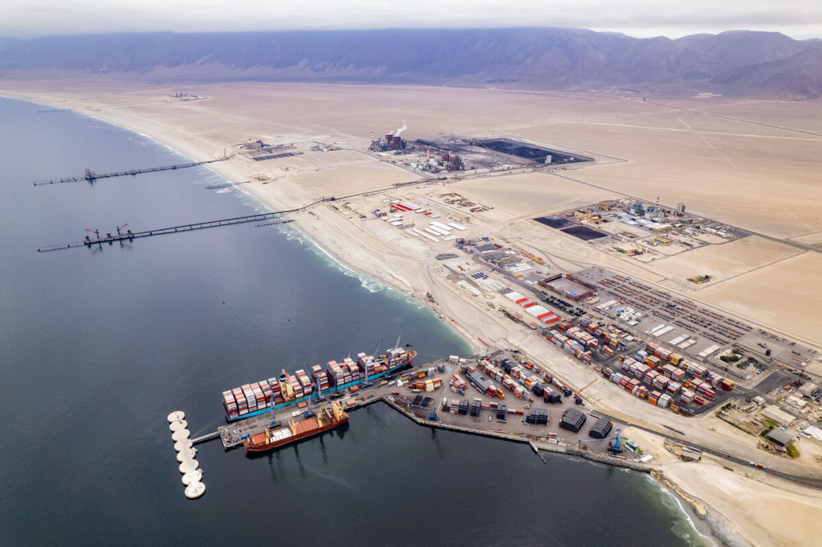
The port of Mejillones—understood as the port-industrial hub located in the bay of Mejillones, in the Antofagasta Region—has exceptional conditions to become one of the most relevant logistical nodes in northern Chile and the Southern Cone of America. Its importance lies not only in its current port capacity but also in its geographical position, its connection to the mining industry, its potential for expansion, and its outlook regarding the future Bioceanic Corridor, an initiative aimed at connecting the Atlantic with the Pacific through Brazil, Paraguay, Argentina, and Chile.

In a country where 94.9% of foreign trade is conducted via maritime routes, port development is not only an economic issue but also a strategic one. The General Directorate of Maritime Territory and Merchant Marine (DIRECTEMAR) has emphasized that the intelligent use of the coastal edge is key to national growth, especially given Chile’s location facing the Pacific and its potential as a platform for exchange for South America.[1].
In this context, Mejillones emerges as a critical infrastructure for Chile’s international integration, as it not only serves the mining sector in northern Chile but can also capture cargo flows from the central-western region of Brazil, Paraguay, and northwestern Argentina, particularly towards Asia-Pacific markets. The following analysis will review the main characteristics and capabilities of the Mejillones port hub; its position regarding the Capricorn Bioceanic Corridor; its comparative advantages, and the conditions and challenges to seize the opportunity it presents.
CHARACTERISTICS AND CAPABILITIES OF A FUTURE STRATEGIC PLATFORM
The bay of Mejillones has been identified for decades as a privileged space for port development. In 1998, the State of Chile declared the Southern Mejillones Bay a Reserved Coastal Area, considering that this area is one of the few that allows for significant port development due to its geographical, bathymetric, and meteorological conditions, as well as the existence of sheltered deep-water bays. That same decree indicated that the Mejillones Port Complex project aimed to develop a port of national and continental reach, oriented to connect Mercosur markets with the Asia-Pacific.[2].
This last point is crucial, as Mejillones was conceived from the outset as a cargo platform with continental projection. One of the reasons for this decision was its location relative to mining production centers. Located 65 kilometers from Antofagasta and approximately 1,440 kilometers north of Santiago, Mejillones is situated in the heart of Chile’s mining north and in a natural position to articulate logistical flows between the center of the South American continent and the Pacific. The port of Mejillones serves as the main port infrastructure for the transfer of solid and liquid bulk in the Antofagasta Region, with nearly three decades of operation and over 63 million tons mobilized since its operations began.[3]. Its strategic value is explained by a combination of factors: a protected bay, suitable depths for large vessels, rail and road connectivity, availability of backup areas, proximity to mining operations, and experience in handling critical cargo for mining and industry.
The Mejillones port hub should be analyzed as a port-industrial system composed of various terminals, logistical services, and support capabilities. In the case of Puerto Mejillones S.A., its facilities allow for the handling of liquid and solid bulk, including mineral concentrates, petcoke, clinker, sulfur, and sulfuric acid. Its Site No. 1 features a mechanized dock with an authorized depth of 14.38 meters, designed to operate Panamax-type vessels of up to 70,000 DWT, while Site No. 2 has infrastructure for the operation of sulfuric acid through discharge and loading pipelines from vessels[4].
In addition to these terminals, Puerto Angamos, a multipurpose terminal also located in Mejillones, has four berths with maximum depths of 13.7 meters, capable of receiving vessels of up to 155,000 tons displacement and 366 meters in length, as well as 134,000 square meters of storage and access via rail and road. Its transfer capacity exceeds 4 million tons annually and includes mobile cranes, container cranes, tractors, and other specialized equipment[5].
The bay also offers a significant operational advantage, as Puerto Angamos benefits from the natural conditions of the Mejillones bay, which allow for a down time associated with bad weather of less than 1% annually; a particularly important attribute in a country where swells and port closures increasingly affect the operational continuity of other ports[6]. For example, as mentioned in a previous report, between 2013 and 2021, there were 6,723 total or partial port closures; the vast majority concentrated between Arica and Los Vilos. The Mejillones bay, due to its characteristics, has shown some resilience against these effects of climate change[7].
From a productive standpoint, in 2025, the Mejillones Port Complex recorded 6.7 million tons transferred; a 16% increase compared to 2024. This performance included 1.3 million tons of containerized cargo, 1.2 million tons of copper, and 0.4 million tons of general cargo, in addition to the commissioning of a new loading site for mineral concentrates at the Solid Bulk Terminal[8].
Finally, the Government of Chile has already incorporated specific improvements for Mejillones within the Corridor Action Plan, such as reinforcing the northern access to Mejillones, aiming to reduce travel times for cargo to the port, and creating rest areas for trucks in Mejillones and San Pedro de Atacama. Meanwhile, the Road Directorate reported in 2026 that routes such as B-24, B-39, and the southern access to Mejillones already have corridor signage, and that the agreement “Works to Enhance the Capricorn Bioceanic Corridor 2025-2035” includes nearly $600 billion in road, logistical, service, and control infrastructure[9].
THE BIOCEANIC CORRIDOR AS A CONTINENTAL SCALE OPPORTUNITY
The Capricorn Bioceanic Corridor aims to connect the central-western region of Brazil with the northern ports of Chile, crossing the Paraguayan Chaco and northwestern Argentina. Its official site presents it as a cooperation initiative among four countries and eight subnational territories: Tarapacá and Antofagasta in Chile; Jujuy and Salta in Argentina; Boquerón, Presidente Hayes, and Alto Paraguay in Paraguay; and Mato Grosso do Sul in Brazil[10].

The Action Plan for the Bioceanic Road Corridor developed by the Government of Chile defines the project as a network of road and port infrastructure aimed at connecting the Atlantic and Pacific Oceans, involving Brazil, Paraguay, Argentina, and Chile. The project highlights that the route connects Brazilian ports with the Chilean ports of Antofagasta, Mejillones, and Iquique, traversing Mato Grosso do Sul, the Paraguayan Chaco, and the Argentine provinces of Salta and Jujuy, reducing transport times by up to 10 days between landlocked regions of Brazil, Paraguay, and the Asia-Pacific.[11]
The Ministry of Economy has reinforced this vision by stating that the corridor seeks to consolidate Chile as the exit point for trade from Brazil, Paraguay, and Argentina to Asia, with 22 strategic infrastructure projects distributed among Iquique, Antofagasta, and Mejillones[12].
If the corridor manages to consolidate, the port of Mejillones could become a natural outlet to the Pacific for agro-industrial, forestry, mining, energy, and manufacturing products from the South American interior. It is important to note that in Mato Grosso do Sul, exports from January to October 2025 reached $9.08 billion, with cellulose, soy, and beef as the main products in its export basket[13]. Paraguay, for its part, recorded total exports of $16.72 billion in 2025, with increases primarily explained by higher sales of meat, corn, and soybean oil[14].

GEOPOLITICAL, NATURAL, AND INDUSTRIAL ADVANTAGES
- The first advantage of Mejillones is its capacity to position Chile as a connector between the Atlantic and the Pacific. Traditionally, Chile has had a natural projection towards the Pacific but also a limited logistical relationship with the South American interior. The Bioceanic Corridor can change this condition by allowing Chile to transition from being merely a coastal extremity of the continent to becoming a connection platform for Brazil, Paraguay, and Argentina.
- Another advantage is its location in the Antofagasta Region, where mining, energy, infrastructure, industry, and foreign trade converge. The description of Puerto Mejillones itself highlights that the Atacama Desert concentrates significant deposits of copper, nitrates, and lithium, whose production is exported through the region’s ports.
- On the other hand, Mejillones has a favorable position due to its proximity to the northern border crossings of Argentina and Chile, noting that it connects via paved roads to the border crossings of Jama, Sico, and Peine, with possibilities of connecting by rail to mining operations in Argentina and Bolivia. This becomes particularly relevant when considering its strategic location regarding the so-called “lithium triangle.”
- The fifth advantage is its status as a complementary port within a regional system. Mejillones should not be viewed as an isolated competitor to Antofagasta, Iquique, or Tocopilla, but rather as part of a larger northern port network, considering that the Bioceanic Corridor identifies Iquique, Antofagasta, the ports in Mejillones, and the terminals in Tocopilla as Pacific ports.
- One of the relevant aspects is the competitive value of Mejillones in relation to the Bioceanic Corridor is its ability to reduce total logistical costs, not just port costs. In foreign trade, competitiveness depends on door-to-door time, operational stability, availability of services, shipping frequency, documentation efficiency, security, and traceability. Therefore, competition will not simply be between ports but among complete logistical corridors.
- Additionally, it is worth noting the availability of space for growth. The decree that declared the coastal reserve of Mejillones considered fiscal backup areas in the Mejillones plain to ensure long-term port development and stability for the master plan.
- Moreover, it should be added that its relative exposure to interruptions of port operations due to bad weather is lower. A protected bay with low down time offers greater logistical predictability. In international supply chains, reliability can be as important as distance. A port that operates with greater continuity reduces uncertainty, improves shipping scheduling, and increases its attractiveness for time-sensitive cargo.
CONDITIONS AND CHALLENGES TO SEIZE THIS OPPORTUNITY
The potential of Mejillones does not automatically guarantee its success. There are a series of challenges and critical conditions for this project to emerge as a true hub regional. From the port’s capacity to absorb this increase in cargo, to security challenges, competition with other nodes, such as Chancay in Peru, and minimizing the effects of potential pressures from some of the involved countries to improve their economic position, road, and rail infrastructure. Below are some of these challenges.
- First, institutional coordination will be decisive. The corridor involves four countries, several regional governments, border crossings, customs, ministries, port companies, transporters, shipping companies, and private actors. The Chilean action plan recognizes that efforts around the corridor have been dispersed among the central government, regional governments, academia, and the business world, making it difficult to integrate information and coordinate effectively. This must also consider the internal issues of the other participating countries and their internal management. One key is that this corridor integrates more, competing with existing routes. A crucial point to overcome this is that, in general, this project seeks to enhance trade exchange with the Asia-Pacific region, and thus should not be seen as direct competition to already established developments, such as the Paraná-Paraguay Waterway, which generally aims to transport cargo to the Atlantic and from there to other regions of the world.
- Border efficiency will also be essential. For the corridor to be efficient, it must be more economical than the option of transporting via maritime routes through the Atlantic, or through a future corridor via the port of Chancay. A corridor can lose competitiveness if the time saved in distance is lost in controls, procedures, waits, or lack of document interoperability. Perhaps an example of this bureaucracy is the already established border crossings and the waiting times at these. Customs simplification, coordination among the four involved countries, digitization, and health coordination are crucial; especially for agro-industrial products.
- Security is a fundamental part of the corridor’s competitiveness. The increase in cargo flow through extensive and sparsely populated areas requires surveillance, route control, safe resting points, and enforcement capacity. Additionally, there is the potential for the port to be used as an exit point for illicit substances or smuggling from the other countries; something similar to what ports like Arica and Iquique have experienced due to the trafficking of Bolivian cargo (the recent seizure of over 100 tons of drugs hidden in wood from Bolivia is an example of this). Cooperation in security in this regard is a fundamental factor for this project to achieve acceptable security levels for international trade; of course, this ensures that Mejillones continues to be considered a safe port for trading with other regions.
- A key element for any project of this magnitude is environmental sustainability. Mejillones is already a sensitive industrial area, so any logistical expansion must consider environmental monitoring, emission control, dust management, efficient water use, coastal edge protection, and community relations standards. An example of this has been the opposition faced by the San Antonio outer port project, where civil organizations have raised hundreds of indications, some valid and others questionable, which have stalled the project. In this sense, Puerto Mejillones declares an integrated management policy focused on operational quality, environmental care, community relations, and safety of individuals, which must be effective and measurable.
- Physical connectivity is another relevant aspect. Currently, the port of Mejillones is accessed via truck routes, either Route 5 for national cases or routes 23 and 27, essential for the flow from the Corridor. Currently, the Corridor is over 80% complete, achieving a key milestone in May of this year with the construction of the Bioceanic Bridge, which connects Carmelo Peralta (Paraguay) with Puerto Murtinho (Brazil) over the Paraná River. Furthermore, existing railways are being restored to have cross-border branches that allow this mode to be the main feeder for the northern ports, in order to reduce, or at least control, CO2, even though this mode is relatively far from materializing[15].
- Finally, Mejillones will require regular maritime services, and for that, it must ensure to shipping companies its near-total availability to allow connections with weekly maritime services to the Asia-Pacific, Europe, North America, and the Caribbean.
FINAL CONSIDERATIONS
Mejillones represents one of the best opportunities for Chile to transform its geography into influence; its protected bay, its depths, its multipurpose infrastructure, its proximity to mining, its expansion areas, and its integration into the Bioceanic Corridor give it a value that far exceeds its current port dimension.
One of the strategic values of this project lies not only in increasing cargo transport capacity but also in positioning Chile as a logistical platform for the Southern Cone towards the Asia-Pacific. If Mejillones can articulate infrastructure, services, security, sustainability, and governance, it can become a central piece of South American physical integration, providing an economic alternative to mining.
Mejillones has considerable natural and industrial advantages. Therefore, it is expected that Chile can convert them into public policies, effective infrastructure, and active economic diplomacy, actively utilizing the Bioceanic Corridor, competing with other ports, such as Chancay. This will only be possible if the country manages to turn Mejillones into a geopolitical node through coordination among the state, regions, ports, the private sector, communities, and international partners.
ATHENALAB TEAM
[1] DIRECTEMAR, “Analysis of Port Statistics.” Available at https://www.directemar.cl/directemar/estadisticas-maritimas/analisis-estadisticas-portuarias
[2] National Congress Library of Chile, decree declaring the Southern Mejillones Bay a Reserved Coastal Area, 1998. Available at https://www.bcn.cl/leychile/navegar?i=126372
[3] Puerto Mejillones S.A., “Who We Are.” Available at https://www.puertomejillones.cl/quienes-somos/
[4] Puerto Mejillones S.A., “Characteristics.” Available at https://www.puertomejillones.cl/caracteristicas/
[5] Puerto Angamos, “Infrastructure and Equipment.” Available at https://www.puertoangamos.cl/infraestructura-y-equipamiento-puerto-angamos/
[6] Puerto Angamos, “Advantages.” Available at: https://www.puertoangamos.cl/ventajas-puerto-angamos/
[7] Mardones, I. 2026. “DT38 | Port Security and Strategic Challenges: Towards a Comprehensive Proposal for the Chilean Port System.” AthenaLab, July 1. Consulted on July 21, 2026.
[8] Mejillones Port Complex, “Mejillones Port Complex Completes Cargo Transfers of 6.7 Million Tons in 2025.” Available at https://mejillones.com/es/cpm/complejo-portuario-mejillones-completa-transferencias-de-carga-por-67-millones-de-toneladas-en-2025/
[9] Road Directorate, Ministry of Public Works, signage and investment of the Capricorn Bioceanic Corridor, January 2026. Available at https://vialidad.mop.gob.cl/2026/01/19/vialidad-inicia-instalacion-de-senalizacion-informativa-del-corredor-bioceanico-de-capricornio/
[10] Capricorn Bioceanic Corridor, official site. Available at https://corredorbioceanico.org/es/
[11] Ministry of Economy, Development, and Tourism, “Action Plan of the High-Level Commission of the Bioceanic Road Corridor,” April 2025. Available at https://www.economia.gob.cl/wp-content/uploads/2025/04/20250410-plan-de-accion.pdf
[12] Ministry of Economy, Development, and Tourism, background of the High-Level Commission of the Bioceanic Road Corridor, January 2026. Available at https://www.economia.gob.cl/2026/01/19/biministro-garcia-lidero-ultima-sesion-de-comision-de-alto-nivel-del-corredor-bioceanico-vial-hemos-impulsado-avances-decisivos-que-generaran-oportunidades-economicas-para-chile.htm
[13] SEMADESC, Government of Mato Grosso do Sul, exports 2025. Available at https://www.semadesc.ms.gov.br/celulose-mantem-lideranca-e-exportacoes-de-ms-crescem-424-no-acumulado-de-janeiro-a-outubro-de-2025/
[14] Central Bank of Paraguay, “Foreign Trade Report – December 2025.” Available at https://www.bcp.gov.py/web/institucional/w/reporte-de-comercio-exterior-diciembre-2025
[15] González Robles, E. (April 30, 2026). “North Hub: A Strategic Response to the Challenge of Chancay.” Navy Journal. Consulted on July 21, 2026.