EXTERNAL COLLABORATION | FASat-Delta: A New Leap in Chile's Space Race
This article was translated automatically and may contain differences from the original. For reference, read the original.
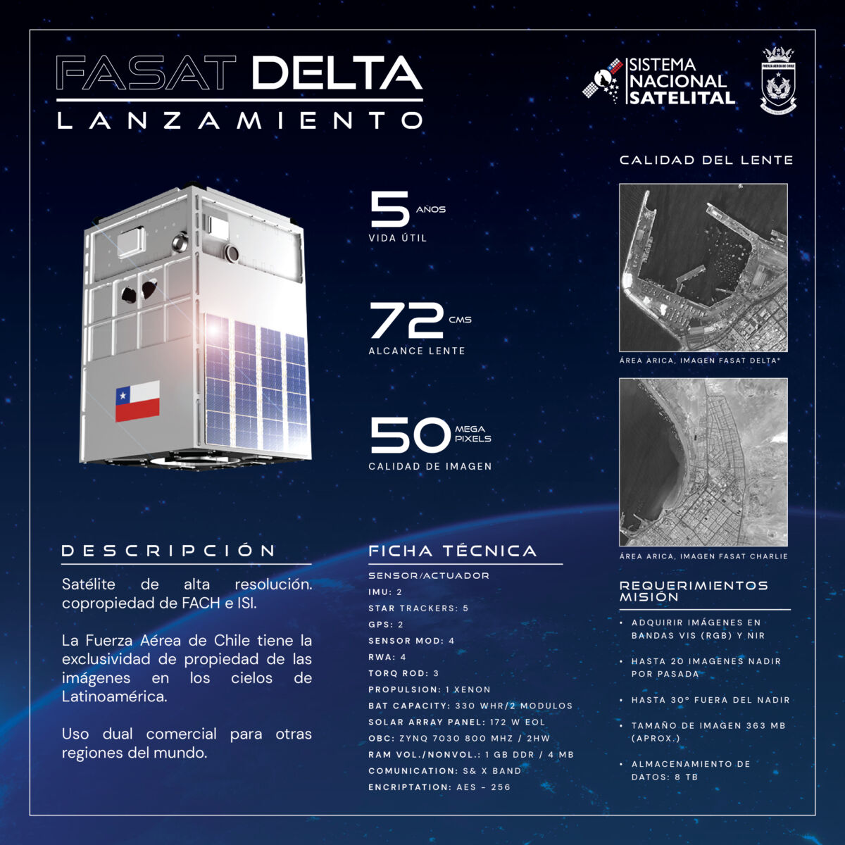
With the launch of the FASat-Delta satellite into orbit, Chile made a significant advancement in its space development this week, substantially enhancing the observation and communication capabilities of a tri-continental country facing challenges such as climate change mitigation and natural disasters. Launched aboard a Falcon 9 rocket from SpaceX, which took off from Vandenberg Air Force Base in California, the satellite will be operated by the Chilean Air Force (FACh), marking four decades of the institution’s presence in space.
Aware of the importance of utilizing these technologies, the FACh began promoting space activities within its ranks as early as the 1980s, preparing a critical mass of professionals capable of integrating the institution and the country into its own space race. In the 1990s, the then Commander-in-Chief, Air General Ramón Vega Hidalgo (RIP), established a multidisciplinary team tasked with taking the first step toward incorporating satellite capabilities into Chile. This first satellite, initially named CondorSat and ultimately FASat-Alfa, would be “the essential first step that must serve to acquire the basic scientific experience that allows us to continue with subsequent, more complex, and advanced stages,” as General Vega described during the commemoration of the institutional anniversary in 1994.
This small 70 kg satellite, which would occupy a position in low orbit (Low Earth Orbit or LEO, for its acronym in English), would perform various tasks of relevance to the country, such as monitoring the ozone layer and capturing images of the national territory across different bands of the electromagnetic spectrum. Unfortunately, due to issues with the separation component of the Ukrainian SICH-1 satellite, to which it was attached to reach its final orbit, FASat-Alfa was unable to enter operation. Viewing this setback as a learning opportunity, the Chilean Air Force continued its efforts to keep Chile in the space arena, successfully launching FASat-Bravo in 1998, a twin satellite to FASat-Alfa, which would serve the same purposes and missions. After completing 13,000 orbits in three years of operation, FASat-Bravo was retired at the end of its operational life in mid-2000. During its time in our national history, it captured and transmitted over 1,200 images of our national territory with a spatial resolution of 2 km per pixel. While this capability to distinguish small structures is insufficient for detailed analysis of the Earth’s surface, this satellite laid the groundwork for its successor, FASat-Charlie.
Launched into orbit in December 2011, FASat-Charlie has far exceeded its expected five-year operational life, and its multispectral sensor has allowed for the capture of over 250,000 images of our territory with a resolution significantly superior to its predecessor, at 1.45 m per pixel in panchromatic mode and 5.8 m in multispectral mode. This capability achieved by FACh engineers and personnel has facilitated multiple scientific analyses and monitoring for national development. From the multispectral analysis of vegetation affected by wildfires to monitoring population growth and over 900 irregular settlements across the national territory, in a joint effort between the Aerophotogrammetric Service of the Chilean Air Force and the Ministry of Housing and Urbanism, FASat-Charlie has left an indelible mark on Chile’s space history and also presents an interesting challenge for our country to continue developing and employing space technologies for the benefit of its citizens.
National Space Program
Recognizing that the national space effort should not rest solely with the Chilean Air Force, as the benefits of such technologies are transversal to all citizens and the entire national industry, the institutional High Command proposed a multisectoral approach to civil authorities to keep Chile among the countries with a presence in the space domain. Thus, the Chilean Air Force, through the project leader, Brigadier General (A) Luis Felipe Sáez C., appointed to the delicate task of designing and implementing the National Space Program, established a national structure and organization that integrates the ministries of the Interior and Public Security, Foreign Affairs, National Defense, National Assets, Transport and Telecommunications; Science, Technology, Knowledge, and Innovation; as well as the national academic community, into this growing and exciting field of space sciences and technologies.
The National Space Program was conceived based on four fundamental pillars: 1) National Satellite System (SNSat); 2) Communications SNSat (SNSat-COM); 3) Regional Space Centers (SNSat-CER); and 4) Talent SNSat (SNSat-TAL). The latter includes the early generation of a critical mass of students through the School Space Program and the implementation of a Master’s in Space Systems and various specialized diplomas, such as those in Space Operations and Geoinformation, aimed at fostering and consolidating professional training in the field.
In terms of infrastructure, the SNSat includes the establishment of a main National Space Center in Santiago. Additionally, in collaboration with renowned universities in the country, the production of small but versatile satellites will begin in Chile, forming the first Chilean constellation in orbit. Meanwhile, the SNSat-CER plans to construct various smaller-scale space centers located in regions, initially in Antofagasta and near the city of Punta Arenas, in the Magallanes and Chilean Antarctic Region.
The path ahead to achieve the ultimate goal is moderately long in duration. For this reason, the multidisciplinary team in charge of this significant national project has managed access to over 250 satellites already in orbit that are continuously observing and capturing valuable information about our planet. Naturally, this vast amount of information and data requires a physical space for storage, which is why the project also involves the implementation of a data lake located in various points across the country to ensure redundancy and data protection against failures. In this regard, the Aerophotogrammetric Service (SAF) of the Chilean Air Force is a key player, as its established capabilities, combined with those from this project, will contribute to the processing and distribution of images to end users. Additionally, the Space Operations Group (GOE), under the Space Directorate of the General Staff of the Chilean Air Force, which is responsible for the successful operation of FASat-Charlie, will be another major player within this space program, leveraging command and control capabilities consolidated after more than 15 years of experience in the institutional space domain. The National Space Center (CEN), which will house the most advanced Geospatial Data Processing Center in the country, and the Regional Space Centers will be the fundamental pieces of this delicate puzzle, enabling both the control of the constellation and the manufacturing of future satellites that our country will place in orbit. Undoubtedly, this requires the best and most modern physical and technological infrastructure, which is why the best experts in the field were brought in to design and define the cutting-edge architecture and technological aspects of what will be the most significant space laboratory our country has had to date.
Our constellation already includes FASat-Charlie, two satellites already in orbit, and the foreign manufacture of FASat-Delta, which was launched and placed in orbit from a Falcon 9 transport rocket by the American company SpaceX. Additionally, the project includes the manufacture of FASat-Eco1 and FASat-Eco2, built entirely in Chile, along with seven microsatellites for scientific use. All of the above will be coordinated under a governance model of the Chilean space system that will effectively integrate various public services, the participation of the academic world, and national private entities interested in space matters. Once the success of this constellation is consolidated, it is anticipated that our first communications satellite will be incorporated in the not-too-distant future, opening up opportunities for the country to become self-sufficient in national connectivity.
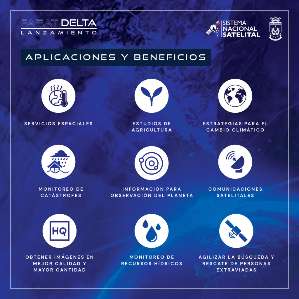
Currently, there is a legitimate concern regarding the necessity of this program; opinions may vary regarding the justification of its cost. Undoubtedly, those who consider themselves detractors of this program will not find utility in what this space technology brings to our country and its residents. For instance, the study of soils to improve conditions and productivity in our agriculture can be easily achieved using images, techniques, and procedures for analyzing satellite images that determine where irrigation should be best applied or how to improve the distribution of crops to increase efficiency, among other things. On the other hand, Chile is a country that constantly faces natural phenomena that directly impact the population. Through Earth observation from space, as a fundamental tool for monitoring irregular urban growth, as well as the various conditions that facilitate landslides, mass removals, and river overflow, active mitigation and prevention measures can be taken for the direct benefit of people, families, and housing infrastructure. Similarly, satellite technologies enable global monitoring of volcanic activity, allowing for timely protective measures with a direct impact on people’s lives. Furthermore, following the occurrence of massive wildfires, earthquakes, and tsunamis—phenomena that have devastated our territory on multiple occasions—satellite observation of the Earth has significantly enhanced the effectiveness of situation assessment, directly impacting affected localities and enabling optimal prioritization and planning of the distribution of much-needed aid.
Finally, is it necessary to access and remain a prominent actor in the space domain? The answer is a resounding YES. The return on investment multiplies fourfold and contributes permanently and directly to the lives of individuals, industry, and the State. Thus, the multisectoral initiative led by the council of ministers and operationalized by the Chilean Air Force and other members of the national academia brings life to and sustains the National Space Program, making it essential to continue along this path of technological and service development. Now, if you are not convinced, look at your phone and use any of the now-common applications, such as Uber, Cornershop, Maps, Google Maps, or any banking application, and then look up at the sky and remember that all this technology in the palm of your hand works thanks to the effort, perseverance, and consolidation of all space technologies.
Francisco Pizarro Aste
Brigadier General (R)
Master’s in Unmanned Systems