Sovereign Maritime Spaces of Chile
This article was translated automatically and may contain differences from the original. For reference, read the original.
El Mostrador, August 26, 2023
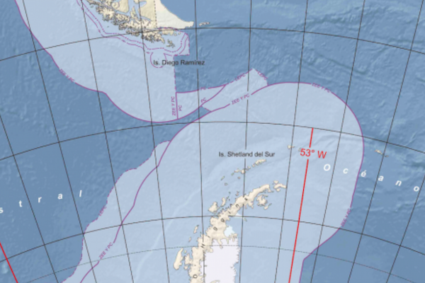
It is important to mention that this graphic has been prepared in accordance with current national legislation and is also linked to the standards established by the United Nations (UN) Convention on the Law of the Sea. This presentation is based on the detailed outline provided in the partial submissions made by the State of Chile to the UN Commission on the Limits of the Continental Shelf.
At this point, we should have few doubts regarding Chile’s maritime condition. Our country is vitally dependent on the sea, whether because over 90% of our international trade moves through it, because more than 95% of the information we receive comes via submarine cables, because we require barges and ships to connect our provinces south of Chiloé, or because a significant portion of the oil and gas that powers the country arrives by this route.
The illustrative graphic of the maritime spaces (which can be seen here) published recently by the Hydrographic and Oceanographic Service of the Navy (SHOA), in coordination with the National Directorate of Borders and Limits of the State (Difrol), which is already generating complaints from our trans-Andean neighbors, is a new testament to the magnitude of our spaces, presenting a different perspective of Chile than what we know through traditional maps, and helping to reinforce the maritime vocation of the nation.
This work, which involved years of preparation, studies, and oceanographic cruises, not only represents the already traditional Exclusive Economic Zone and Continental Shelf but also incorporates the outer limits of this same shelf related to the Provinces of Rapa Nui and the Chilean Antarctic Territory.
It is important to mention that this graphic has been prepared in accordance with current national legislation and is also linked to the standards established by the United Nations (UN) Convention on the Law of the Sea. This presentation is based on the detailed outline provided in the partial submissions made by the State of Chile to the UN Commission on the Limits of the Continental Shelf.
This graphic, which uses a style similar to that employed by Argentina to depict what it claims as its own, consolidates, in a single image, the status of a tricontinental country with its maritime spaces in all their dimensions, and, in passing, reminds us that our future and opportunities are definitively tied to the sea.
In the current national environment, where bad news prevails, news like this work should fill us with pride, as it demonstrates that when two or more governmental organizations, in this case, SHOA and Difrol, work together towards a common goal, significant achievements can be obtained. Hopefully, this capacity for inter-agency collaboration can permeate the rest of the State.
We can only hope that this initiative, which clearly and simply demonstrates what has been a historical continuity in Chile’s position and approach regarding these maritime spaces, does not cause too much uproar among our neighbors across the Andes and that they accept our sovereign rights over this maritime area with ‘humility,’ and if that is not the case, as they say in Colombia, what a pity for you.
Ignacio Mardones Costa
Head of Development and Strategy at Athenalab